Route Descriptions: New York
Route descriptions courtesy of Mark Hansen
Erie to Buffalo, New York: Today's route follows the road along the Lake Erie shoreline to West Seneca, a suburb of Buffalo. From Pennsylvania, it passes into Chautauqua Co, New York. Its name is said to be the only word in the language of the Erie people that is still in use. Its meaning is unknown, so thoroughly were the Erie annihilated by the Iroquois in the Beaver Wars. Chautauqua Co is the namesake of the Chautauqua Movement, an adult education and social enlightenment program that flourished in the late 18th and early 19th century. It incorporated elements of the lyceum and the camp meeting in its gatherings, called "Chautauquas," in cities and towns throughout America. The Chautauquas often had social reform themes. Among the speakers were politician William Jennings Bryan, prison reformer Maud Ballington Booth, settlement house pioneer Jane Addams, humorist Opie Reed, and Russell Conwell, a Baptist minister who delivered his inspirational "Acres of Diamonds" speech over 5000 times on the Chautauqua circuit. The first Chautauqua Assembly was organized in 1874 at a campground on the shore of Lake Chautauqua (10 mi southeast of Westfield). Led by a Methodist bishop, its purpose was to train Sunday School teachers. (As a visual aid, the founders created Palestine Park, a scale model (21 in = 1 mi) of the Holy Land. It may still be seen.) The Chautauqua Institution continues the program of the Chautauqua Assembly today. Novelist Salman Rushdie was attacked and severely injured while speaking there in 2022.
The Chautauqua Co seat of Jamestown is at the southeast end of Lake Chautauqua (another 8 mi southeast). It is the birthplace of comedian Lucille Ball and naturalist Roger Tory Peterson, the author of the popular bird guides. Nearby Frewsburg was the home of attorney general, Supreme Court justice, and Nuremberg Trial prosecutor Robert H Jackson. Jamestown was a center of furniture manufacture and the home of the company that produced the Crescent wrench. The areas near the shore of Lake Erie are known as the "Grape Belt," benefiting from the elevated precipitation (particularly snowfall) and moderated temperatures of the "lake effect." Westfield, a mile or two inland from Barcelona (and its lighthouse), was and is a center of Concord grape production. It was formerly the headquarters of Welch's, founded by a local man who invented a pasteurization process for grape juice. Mogen David has a winery in the town as well.
Westfield was the home of Grace Bedell, the 11-year-old girl who wrote to Abraham Lincoln during the 1860 campaign to suggest that if he were to "let your whiskers grow ... you would look a great deal better for your face is so thin." On his way from Springfield to his inauguration in Washington in 1861, Lincoln stopped his train in Westfield to meet the girl and show her his new beard. A pair of statues in a park in Westfield imagines the meeting between the little girl and the tallest president (6'4").
Dunkirk, just past the first SAG stop, was the original terminus of the New York and Erie Railroad, a major railway known throughout its life as the Erie. Its origination point was Jersey City, New Jersey. Construction began in 1836, reaching Dunkirk in 1851. It was the first through-route trunk line to link the East Coast and the Midwest, beating the Pennsylvania Railroad by a year and the Baltimore and Ohio (B & O) Railroad by two. (The Pennsylvania Railroad pieced together a route from Philadelphia to Pittsburgh in 1834, but it required several changes in conveyances, including onto canals.) Steamboat service continued across Lake Erie to Detroit. In 1859, the Erie became the first major trunk carrier to go bankrupt. Many would follow. Reorganized, in the 1860s, it was the subject of the "Erie War," a struggle for control of the company between steamship baron Cornelius Vanderbilt and financiers Daniel Drew, James Fisk, and Jay Gould, won ultimately by Gould.
In 1869, the Erie moved its locomotive and car shops to Buffalo. It leased the facilities it left behind in Dunkirk to a new company, the Brooks Locomotive Co. Brooks built steam locomotives for the Erie and many other railroads. In 1895, a Brooks 4-6-0 set a new land speed record of 92.8 mph over a timed mile on a run from Chicago to Buffalo on the Lake Shore & Michigan Southern. Brooks merged into the American Locomotive Co (ALCO) in 1901. It built ALCO-Brooks locomotives in Dunkirk until 1934, when ALCO repurposed the shops for other product lines. It closed in 1962.
In Silver Creek, just after Rt 5 passes under the train tracks, Jackson St (on the left) passes under the same tracks. The (further) bridge over the tracks is a rare example of a skew (helicoidal) arch, an arch set on an angle. It "required cutting each stone in the barrel [of the arch] to an exact curve, and as such a bridge like this represents the finest in masonry craftsmanship." It is identified by a marker on Jackson St. Just beyond it, near the lake shore, is a marker commemorating the steamer Erie, which in 1841 caught fire and sank, killing over 200 people, mostly immigrants headed west.
As Chautauqua Co ends and Erie Co begins, the route passes through the Cattaraugus Reservation of the Seneca Nation of Indians, one of three federally-recognized groups of Senecas. The 34 sq mi reservation lies along Cattaraugus Creek on the borders of Chautauqua Co, Erie Co, and Cattaraugus Co to the east. The Seneca Nation of Indians has three other reservations in Cattaraugus Co. Another group, the Tonawanda Band of Seneca, has a 12 sq mi reservation to the north in Erie, Niagara, and Genesee Co. A third group, the Seneca-Cayuga Nation, is in Oklahoma. The Seneca people used to occupy the Buffalo Creek Reservation, a 78 sq mi parcel encompassing large parts of today's Buffalo and its eastern and southern suburbs, including West Seneca. It and 11 other reservations were deeded to them by the Treaty of Big Tree in 1797. White settlers began to buy up reservation land in the 1820s. Other lands were ceded by the Seneca under the terms of the treaties in 1838 and 1842, part of the Andrew Jackson administration's policy of Indian removal. In the course of the machinations, the Buffalo Creek Reservation was simply dissolved. In Erie Co, Angola is named for the Portuguese colony in southwest Africa, where the town's Quaker residents supported missionaries.
Willis Carrier, the inventor of modern air conditioning (1902), was born and grew up in Angola. (He was perhaps inspired by the cooling breezes off Lake Erie.) In Highland-on-the-Lake, a home designed by Frank Lloyd Wright, Graycliff, overlooks Lake Erie and Buffalo. It was the summer home of Darwin and Isabelle Martin, who had earlier commissioned Wright to design their home in Buffalo. The city of Lackawanna was named for the Pennsylvania steel company that operated a mill in the city.
The city of Buffalo began as a harbor on the Buffalo River. In
1825, it became the western terminus of the Erie Canal. Almost immediately, it
became the largest grain port in the world. Although later surpassed by Chicago,
it continued to be one of the country's largest transshipment hubs. It also
developed into a major iron and steel manufacturing center. Buffalo has the
earliest urban park system in the United States and a number of distinguished
buildings, including the Guaranty Building by Louis Sullivan and the home Frank
Lloyd Wright designed for Darwin and Isabelle Martin. The author of The Great
Gatsby, F. Scott Fitzgerald, grew up in Buffalo. Two presidents made their
homes in Buffalo. Grover Cleveland, who served as mayor of Buffalo and governor
of New York, was the only Democrat to serve as president between 1860 and 1912.
He is also the only president to serve non-consecutive terms (1885-1889,
1893-1897). Millard Fillmore, a Whig, became president when Zachary Taylor died
in 1850 and served the balance of Taylor's term (1850-1853). Numbered among our
least distinguished chief executives, he supported the Compromise of 1850,
which brought California into the Union as a free state in exchange for passage
of the Fugitive Slave Act. Incensed by the latter, anti-slavery Whigs denied
Fillmore the party's nomination in 1852. He was the last Whig president. Chief
Justice John Roberts was also born in Buffalo.
Upstate New York. The next four days of cycling take the tour across Upstate New York from Buffalo on Lake Erie to Troy on the Hudson River. The last third of today’s route and all of tomorrow’s traverse the Finger Lakes Region, passing north of a series of eleven long, thin lakes each oriented north-south, none wider than 3.5 mi. They were gouged by glaciers during the Ice Age of 95,000 to 20,000 years ago – the same Ice Age that formed the Great Lakes. Although mapped they look like fingers, the designation “Finger Lakes” dates only to the 1880s.
In the 17th and 18th century, Upstate was the home of the Iroquois, as the French called them, or as they called themselves, the Haudenosaune, “People who build the longhouse.” They were sedentary peoples who lived in longhouses and cultivated the “Three Sisters” – corn, beans, and squash – supplementing their diet with hunted game. They were five distinct tribes – from west to east, Seneca, Cayuga, and Onondaga south and east of Lake Ontario and Oneida and Mohawk south of the St Lawrence River into the valleys of the Mohawk River and upper Hudson. (Later there was a sixth tribe, the Tuscarora, in the upper Susquehanna Valley.) The Five (Six) Tribes (as the British called them) shared a common culture and spoke related and mutually comprehensible languages. Except for a few Senecas and Cayugas in Oklahoma, their descendants still live in the region in communities and on small reservations. New York City long had a famous community of Mohawk ironworkers who braved the dizzying heights constructing the city’s skyscrapers.
European Americans settled the region west of the Hudson Valley in the late 18th into the early 19th century, primarily moving westward from New England. Beginning in the 1820s, during the Second Great Awakening in the United States, the people of the Finger Lakes and western New York experienced a series of religious revivals of such fervor that the region became known as the “Burned-over District.” The period produced a spiritual renewal of the evangelical Protestant faiths – particularly Congregational (“Puritan”), Methodist, and Baptist – a new, American religious faith, the Church of Jesus Christ of Latter-day Saints, the Mormons; nonconformist religious, cultural, and political movements like Spiritualism, vegetarianism, and communalism; and movements for social and moral reform, above all, for the abolition of slavery and the rights of women. The area was also the gateway for the development of the American West.
The route of the next four days parallels the course of the Erie Canal, begun from Troy in 1817 and completed at Buffalo in 1825. (The first two days’ routes are many miles south of the Canal; the route first engages the Canal just west of Syracuse and stays with it through Troy.) It was an engineering feat of the first order: 363 miles, crossing rivers and streams over 18 aqueducts and passing through 83 locks as it rose 571 feet from the Hudson River at Albany to Lake Erie at Buffalo. Later canals extended the network to the south and the north. People and goods passed on the canal on barges towed by mules. (Here is Bruce Springsteen’s cover of the 1903 folk song “Low Bridge.). The Erie Canal was the first economical passenger and trade route between the Great Lakes and the Atlantic seaboard. It shortened the travel time from Albany to Buffalo from two weeks to five days. Even with the tolls, it reduced the transport cost for a barrel of flour shipped from Rochester to Albany by 75 pct, from $3 to 75 cents. It inaugurated New York City as the nation’s great Atlantic port, eclipsing Baltimore and Philadelphia. It fostered the development of commercial agriculture in Upstate New York and the Great Lakes and the expansion of markets for eastern manufactures in the West. By opening the vast territories west of the Appalachians for trade on a large scale, the Erie Canal made New York, truly, the Empire State.
West Seneca to Victor: The first towns along today’s route, West Seneca and Elma, were part of the Buffalo Creek Reservation that the Seneca relinquished in the Treaty of Buffalo Creek in 1842. Among the first settlers were Alsatian immigrants of German descent, members of a radical pietist religious sect called the Community of True Inspiration. They lived and worked communally and owned property in common. The Inspirationists called their settlements in West Seneca and Elma the Ebenezer Colonies. By 1855, they felt impinged upon by the growth of Buffalo. They picked up and moved to Iowa, where they founded the Amana Colonies. (A business that spun off from the Amana colonies manufactured refrigerators, air conditioners, and, in 1967, the first microwave ovens.)
The next county east, Genesee, was formed out of the Holland Purchase, a 500 sq mi parcel bought by an American speculator and Dutch investors and offered for sale to settlers. The agreement required the Holland Land Company also to buy out Indian land claims. The chief of the Seneca, Red Jacket, opposed the sale but “freely-distributed liquor and trinkets given to the women” carried the day for the investors. The Genesee Co seat, Batavia, 8 miles northeast of Alexander, was founded in 1802 and named after the second Dutch republic. The office of the Holland Land Co in Batavia is a National Historic Landmark. In 1826, Batavia resident William Morgan disappeared. He was a disgruntled member of the Freemasons who had threatened to reveal their secrets and everybody believed that Masons had killed him to silence him. His disappearance coincided with a backlash against the secret order among religious communities aroused by the Great Awakening. His presumed death contributed to the formation of America’s first third party, the Anti-Masonic Party, in upstate New York in 1828. Over a period of six years, 14 Anti-Masons won seats in Congress from New York. In the 1832 election, the Anti-Masonic presidential candidate, William Wirt, won 8 percent of the vote and state of Vermont.
Three miles south of Alexander in Wyoming Co is Attica, the site of Attica Prison. In 1971, inmates took over the prison in a protest against the conditions, taking 42 corrections staff hostage. Four days later, law enforcement officers stormed it and regained control. 43 people died in the uprising, 33 inmates and 10 corrections staff, 39 of them (30 inmates and 9 staff) killed by law enforcement during the assault. It was the deadliest prison riot in American history. The prison’s inmates once included the prolific bank robber Willie Sutton, a practical sort, who said he held up banks “because that’s where the money is.”
The farmland in Genessee Co was considered to be the richest in New York. For a decade or two after the construction of the Erie Canal, the area was a leading producer of wheat, until producers on larger acreages and more productive land in the West out-competed them. On the way into Avon, a few hundred yards past Inverness Cemetery (on the right), the route crosses the Genesee Valley Greenway. It was the course of the Genesee Valley Canal, which extended 124 miles parallel to the winding Genesee River between the Erie Canal at Rochester and the Allegheny River in southern New York. Built in 1840, it closed in 1878. Its course was then used as the route of the Genesee Valley Canal Railroad. Avon, the second SAG stop, is just inside Livingston Co and the Finger Lakes Region. The western-most of the Finger Lakes, Lake Conesus, is six miles south.
During the Revolutionary War, the Iroquois were allied with the British. A large Seneca village called Little Beard’s Town stood 12 mi southwest of Avon at present-day Cuylerville. In 1779, a Continental Army force commanded by Gen. John Sullivan destroyed the village and surrounding crop fields. It was the furthest point reached by the Sullivan Expedition, a scorched-earth campaign ordered by Gen. George Washington to “take the war home to the enemy to break their morale.” A day before, Senecas had ambushed an American scouting patrol 20 miles south of Avon, killing at least 16 soldiers. In four and a half months, the Sullivan Expedition razed 40 Iroquois villages, displaced thousands, and virtually destroyed the Iroquois Confederacy.
From the early 1800s until the early 1900s, Avon was known for the sulfur springs in the south part of the town. They drew thousands to take the healing waters at spas and resorts. East of Avon, Lima, named after Old Lyme, Connecticut, is accordingly pronounced like the bean, “lyme-a.” Genesee College in Lima was the alma mater of Belva Ann Lockwood (nee Bennett), the first woman admitted to practice before the US Supreme Court (in 1879). Six miles south of Lima, on the western side of Hemlock Lake, the O-Neh-Da Vineyard is the oldest maker of sacramental wine in the Western Hemisphere, established in 1872 by the Rt Rev Bernard J McQuaid, the first bishop of the Roman Catholic Diocese of Rochester.
The city of Rochester is 25 miles north of Lima. It is the seat of Monroe Co.
The arrival of the Erie Canal in 1823 turned it into the country’s first
boomtown. It became a milling center for western wheat, calling itself the
“Flour City.” In the 19th century, Rochester was the home of the abolitionist
ex-slave Frederick Douglass and the suffragist Susan B Anthony. It was the
birthplace of the Gannet newspaper chain and the Western Union telegraph
company. In the late 19th and early 20th century, it birthed the optical
company Bausch & Lomb; Eastman Kodak, the manufacturer of photographic
cameras and film; and Xerox, the inventor of photocopying. (No wonder that the
top-ranked department at the University of Rochester is Optics!) A short
distance north of the route into Victor, the day’s destination, is Mendon, a
small town in southeastern Monroe Co. Mendon was the residence of Brigham Young
and Heber Kimball when they received baptism in the Church of Christ, as the
Mormons were called in that early day, in 1832. Both became evangelists for the
faith and members of the inner circle of leadership, called the Quorum of
Twelve Apostles. Young succeeded Joseph Smith Jr as the Mormon Prophet after
Smith’s murder in Illinois in 1844 and led the exodus of the faithful to Utah
in 1847. The place of origin of the Mormon church is just off tomorrow’s route.
Victor to Syracuse: Today’s route from Victor to Salina is particularly alive with history: the origin of the Mormons, the birth of the women’s suffrage movement, the advance of abolitionism, and the route’s first engagement with the Erie Canal. The Mormon Prophet, Joseph Smith Jr, lived with his family on a farm in the town of Manchester in Ontario Co (on route). In 1823, when he was 17, he had a vision of an angel named Moroni, who directed him to golden plates hidden in a high nearby hill he called Cumorah, a two miles north of your path through the village of Manchester. The plates contained the story of Christ’s appearance in the Americas after his resurrection and the events that followed. The angel taught Smith to read the text, written in “reformed Egyptian,” using a seer’s stone but prevented him from taking the plates from Cumorah. Finally, after four annual visits to the hill, Moroni relented and allowed Smith to take the golden plates to his own farm (two miles north of Hill Cumorah in Wayne Co), where over many months he dictated the translation of the Book of Mormon to his wife Emma and other scribes. In 1830, a Palmyra printer, E. B. Grandin, published the Book of Mormon, considered by the LDS Church to be sacred scripture. (Palmyra is six miles north of Manchester.) The Church maintains Smith’s farm, Hill Cumorah, and Grandin’s printing shop as pilgrimage sites.
Smith was not the area’s only spiritual seeker, however. In 1848 in Hydesville, five miles east of Palmyra, two sisters, 15-year-old Margaretta Fox and 11-year-old Kate Fox, began to communicate with the spirit of a murdered man who haunted their farmhouse home. The spirit conveyed his messages through noises that sounded like raps on a table. The “rapping” followed the sisters when they were sent to live with siblings in Rochester. Their elder sister Leah Fish became convinced of their claims of communication with the spirit world. In 1849, the sisters gave a public demonstration at a séance in a hall in Rochester, touching off a movement known as Spiritualism. Not even their confessions 40 years later to having perpetrated a hoax – they produced the sounds, they said, by cracking the joints of their toes – dampened the enthusiasm of its adherents. In 1844, 150 admirers of the French socialist Charles Fournier formed a utopian community in Hopewell called the Ontario Union. It lasted a year.
The SAG stop in Geneva is on the shore of Seneca Lake, the largest (43,343 aces) and deepest (618’) of the Finger Lakes. At the south end, 35 miles away, is Watkins Glen, home of the Watkins Glen International race track, for 20 years the host of the United States Grand Prix. For 100 years after the coming of the railroad, farmers in the Finger Lakes region fed dairy cattle on pastures in the valleys. The region is now the center of New York’s wine industry, the second largest in the country, after California’s.
The route east from Geneva to Waterloo and beyond to Seneca Falls follows the Seneca River. The Seneca is the outlet for both Lake Seneca and Lake Cayuga. In the 1810s, it was dammed and locks added to support navigation between Seneca Falls and Waterloo. In 1825, it was extended into the Cayuga-Seneca Canal, connecting to the Erie Canal at Montezuma, on the Seneca River north of Lake Cayuga. Waterloo is the primary county seat of Seneca Co and the route passes right by the courthouse. In 1866, a year after the end of the Civil War, the village declared a day of observance and honor for the war dead. In the 1960s, Congress recognized Waterloo as the originator of Memorial Day. A few miles further is the town of Seneca Falls, “the birthplace of women’s rights.”
In 1848, the Seneca Falls Convention met in the Wesleyan Chapel Methodist Church (126 Fall St) “to discuss the social, civil, and religious condition and rights of woman.” It was the first women’s rights convention in American history, probably in world history. Elizabeth Cady Stanton, a Seneca Falls resident, and a group of local Quaker women organized the convention around the visit of Lucretia Mott, the Quaker anti-slavery activist and advocate for women’s rights. Other notable participants included Amy Post, Eunice Newton Foote, Amelia Bloomer, Mary Ann M’Clintock Jr, Martha Coffin Wright, and the abolitionist Frederick Douglass. (Elizabeth Cady Stanton and her closest comrade in the struggle for equality for women, Susan B Anthony, did not meet until 1851.) The Convention adopted eleven resolutions. The ninth called for women “to secure to themselves their sacred right to the elective franchise,” the first demand for women’s suffrage ever put forward. The site of the Convention is now the Women’s Rights National Historical Park, which will be on your left in the center of town on Fall St. The Elizabeth Cady Stanton home is across Van Cleef Lake, a portion of the Seneca River dammed to enlarge the canal, at 32 Washington St.
Past Seneca Falls, the route crosses the Seneca River north of its outlet from Lake Cayuga. Lake Cayuga is the second-largest of the Finger Lakes. At its southern end, 40 miles away, is Ithaca, the home of Cornell University. Cornell is both a private Ivy League university and the public land-grant (agricultural) college of New York. Its alma mater is “Far above Cayuga’s waters.” Four miles down the Cayuga-Seneca Canal, off the route, just north of the New York State Thruway (I-90), is Montezuma, where the Cayuga-Seneca Canal met the Erie Canal. The Canal originally crossed the Montezuma Marsh at the outlet from Lake Cayuga into the Seneca River. (The area is still a National Wildlife Refuge.) In 1834, the state began a program of improvements on the Canal called the First Enlargement. At Montezuma, the state constructed an 840’ aqueduct to carry the Erie Canal over the Seneca River. Constructed between 1849 and 1857, it was the second-longest of the aqueducts on the canal. In 1905, the state began even more ambitious improvements on the canal system, widening and deepening them to create the New York State Barge Canal. In the Syracuse area, the project moved the Erie Canal to the north of the original route. The portion that passed through Montezuma was abandoned and the Seneca River Aqueduct was partially demolished to facilitate traffic on the Cayuga-Seneca Canal. Ten of the 31 limestone arches that supported the towpath remain as ruins, however.
In 1781, New York designated a 3100 sq mi area in the center of the state as the Central New York Military Tract, intending to reward men who enlisted in the Continental Army with land grants. The New Military Tract included the entire present-day counties of Seneca (county seat Waterloo), Cayuga (Auburn), and Onondaga (Syracuse). The Tract included reservations for the Cayuga people on either side of Lake Cayuga and the Onondaga people south of Lake Onondaga, including today’s Syracuse. The state extinguished their claims in full (Cayuga) or in part (Onondaga) within a decade, actions that are still the subject of constitutional and legal dispute. The Onondaga Nation now has a 9 sq mi reservation south of Syracuse. The Cayuga Nation of New York has a headquarters in Seneca Falls but no reservation; the tribe has been purchasing property as it can on the north side of Lake Cayuga. The second SAG stop is in the community of Throop (named for a New York governor and pronounced “troop”).
Three miles south, on the north shore of Lake Owasco, is the city of Auburn. It is the Cayuga Co seat and (like Rochester and Seneca Falls) a city whose historical significance is out of proportion to its population. For 50 years, Auburn was the home of William H Seward, governor and senator from New York, Abraham Lincoln’s most formidable rival for the 1860 Republican presidential nomination, and Lincoln’s secretary of state. As governor and senator, Seward was a staunch opponent of slavery and a defender of free Black persons and fugitive slaves alike. His wife Frances opened their home to runaways as a station on the Underground Railroad. Seward’s diplomacy during the Civil War prevented French and British recognition of the Confederate States government and foreign intervention in the conflict. In 1859, Frances Seward sold Harriet Tubman a farm in Fleming, a few miles south. Often called “Moses,” Tubman escaped slavery in Maryland in 1849 but returned south the next year to guide members of her family and other enslaved people to freedom, risking the harsh penalties of the Fugitive Slave Act (1850), in all conducting more than 70 fugitives on the Underground Railroad to Canada over the next dozen years. During the Civil War, Tubman worked as a nurse, scout, and spy for the Union Army. She moved her parents back from Canada to the farm in Fleming, married a Black Civil War veteran 22 years her junior, and late in life opened a home for aged Black people next to her farm. William and Frances Seward and Harriet Tubman are buried in Auburn. Abner Doubleday, a Union Army general and the (falsely) purported inventor of the game of baseball, grew up in Auburn. So did Annie Edson Taylor, who was the first person to survive the drop over Niagara Falls (in a barrel in 1901 at age 63). The New York state prison in Auburn was the site of the first execution by electrocution in 1890.
Five mi east of Auburn (6 mi south of Elbridge) in Onondaga Co, on the north end of Skaneateles Lake, is the town of the same name. In 1844, 150 people formed another utopian community based on Charles Fourier’s ideas. It lasted for two and a half years. (There were many Fourierist communities in the United States, the most famous Brook Farm in West Roxbury, Massachusetts, which endured for 5 years.) Skaneateles Lake and Otisco Lake two miles east are the last of the Finger Lakes. North of Camillus, just after the route turns right on Devoe Rd, the route crosses the Erie Canal. This part of the original canal was enlarged in the 1840s but abandoned in the 1900s when the Erie Canal was rerouted north of Onondaga Lake.
From there, the route zigzags north around Onondaga Lake and
then back south to the town of Salina, on the east shore of the lake. The
town’s name (pronounced Sa-lye’-na) is derived from the Latin word for salt.
There were many salt springs in the area, which the settlers used to collect
salt by evaporation. Commercial producers of salt drilled wells to mine it. The
Salt Museum in Onondaga State Park in the village of Liverpool tells the story.
Liverpool itself was originally called Little Ireland in reference to the Irish
immigrants who constructed and operated the Erie Canal. They boiled potatoes in
the saltwater to make salt potatoes, which may still be found on menus in the
Syracuse area. In the 19th century, because of its salt industry, Syracuse
called itself the “Salt City.” The founders of many Upstate cities and towns
were fond of names from the classical Mediterranean – pace Ithaca, Utica, Troy,
Rome, Attica, Palmyra. Syracuse is named for a city for the Greek colony of Syracuse,
located in Sicily. Like other Upstate cities, it was a center of appliance and
electronics manufacturing, the headquarters of Carrier (air conditioners) and
Crouse-Hinds (traffic signals) and General Electric plants producing
televisions. President Joe Biden (Law) and football great Jim Brown are alumni
of Syracuse University. Brown was also a standout player on Syracuse’s fabled
lacrosse team, playing a sport invented by the Native peoples of New York and
Ontario.
Salina to Utica: Today’s route exits the Syracuse metro area a little north of the original Erie Canal. The suburb of Lyncourt is an Italian American enclave. Minoa – there is another classical Mediterranean name – was built on abandoned railyards of the New York Central. Much of the route flirts with the boundary between Madison Co, immediately east of Syracuse, and Oneida Co, of which Utica is the seat. The Oneida people are known as “America’s first allies.” During the war of American independence, the Oneida cast their lot with the American revolutionaries against their Iroquois brethren, particularly the Mohawk and the Seneca, who supported the British. Because of recent rulings on Native treaty claims, the Oneida Nation now controls 18,000 acres on the east side of Lake Oneida in Oneida Co and Madison Co, about 5 mi north of Canastota.
The route reconnects with the original Erie Canal in Canastota, in Madison Co. It follows the Canal to Durhamville, in Oneida Co. The original Erie Canal swept southwest from Rome, around Oneida Lake and Onondaga Lake, through Durhamville and Canastota to Syracuse. The new barge canal coursed directly west through Oneida Lake and the Oneida River into the Seneca River and on west. The 70-mi stretch of the original Erie Canal from Frankfort, east of Utica, to Syracuse was called the Long Level, the terrain having so few obstacles that the Canal had no locks. It was here that the Erie Canal crossed the subcontinental divide between the Great Lakes basin and the Hudson River basin, which accounts for the relative “flatness.” The segment of Canal remnants between Canastota and Durhamville is part of the 36-mi Old Erie Canal State Historic Park.
Small is it is, Canastota had a role in the abolitionist politics of the period before the Civil War. In 1852, in a Dutch Reformed Church on S Peterboro St – there is a marker at Railroad St, two blocks south of the route – the Liberty Party convened to nominate its candidate for president of the United States. Founded in Albany in 1840, the Liberty Party was the first political party advocating the abolition of slavery. By 1852, however, it was already in decline, having thrown its support to the Free Soil Party and its candidate, former president Martin Van Buren, in 1848. (Van Buren received 10% of the national vote, 26% in New York.) The participants in the 1852 convention included Frederick Douglass, the Rev Jermaine Wesley Loguen, an AME preacher from Syracuse and an escaped slave himself, and Gerrit Smith, perhaps the most radical abolitionist of the day, the financial and political patron of Frederick Douglass, Harriet Tubman, John Brown, and the abolitionist movement. Smith lived in Peterboro, 9 mi south of Canastota. The orientation of the town was so radical that it sponsored a Fugitive Slave Convention in 1850 – the year of the passage of the Fugitive Slave Act. In the words of a contemporary abolitionist preacher, it was one of “yet two places where slaveholders cannot come,” the other place, “Heaven.” (Today, it is the home of the Abolition Hall of Fame.) The Convention ended inconclusively but Smith himself was elected to Congress as an independent running on an abolitionist platform.
At the other end of the Canal segment, Durhamville was the site of barge repair and barge construction works. Just east of Oneida, at the marked stop, is Cross Island Chapel, a little frame chapel in the middle of a pond, which claims to be the world’s smallest church. Off the route, a mile south of Oneida, is a village named Oneida Castle. In the 18th century, it was the site of a large Oneida village called Kanonwalohale. The village was enclosed within wooden palisades and a moat, fortifications that the settlers in the region referred to as a “castle.” In 1780, during the Revolutionary War, the village was sacked by Mohawks led by their chief, Joseph Brant. The attack was retribution for the actions of the Oneida, allied with the Americans, against the Mohawks, allied with the British.
Further south beyond Oneida Castle was one of the most successful and longest enduring of the many utopian communities that sprouted in America during the Second Great Awakening. John Humphrey Noyes founded the Onieda Community in 1848. It was a religious society that professed the doctrine of Christian perfectionism, the belief that mankind could be free of sin and realize Christ’s kingdom in this lifetime. To that end, the community practiced reforms to communal life, including communal property, group marriage (“free love”), male continence, and mutual criticism. Its 300 members worked in a variety of craft enterprises on 160 acres straddling the boundary of Madison and Oneida Co. In 1862, the Oneida Community built the Oneida Community Mansion House for communal living quarters. Internal divisions and external pressures led to the dissolution of the Community in 1881. (Noyes, who received a tip that he would be indicted for statutory rape, fled to Canada.) It reconstituted itself as a joint-stock company. Now known as Oneida Limited, it is one of America’s largest manufacturers of stainless steel and silverplated cutlery and tableware. The company is based in Sherrill in Oneida Co, about four miles southeast of the town of Oneida.
The Oneida Community was centered about a half mile to its southwest in a hamlet now called Kenwood. In Oneida Co, south of Westmoreland (on the route), Clinton is the home of Hamilton College. The poet Ezra Pound and the psychologist B. F. Skinner were Hamilton alumni; Alex Haley taught there at the time he began work on Roots. The voiceover artist Susan Bennett, the American voice of Apple’s “Siri,” was born in Clinton. The area around Utica includes the communities of New York Mills, Washington Mills, and Clark Mills, their names a reference to the textile mills that in the 19th century lined the tributary creeks along the Mohawk River. In 1827, the Rev George Washington Gale, a Presbyterian minister, founded a college, the Oneida Institute of Science and Industry, in Whitesboro (on the route). It was a manual labor college – students worked as well as studied. Despite its name, its curriculum focused on philosophy, ethics, and religion. Like Gale, the Oneida Institute had a strong moral commitment to abolitionism. It was supported financially by two wealthy abolitionists, Arthur and Lewis Tappan. The Oneida Institute was the first college in the country to admit Black students without restrictions. It typically enrolled around a dozen. The college closed its doors in 1843 but not before it established a model for other colleges with an activist mission, having a particularly strong influence on Western Reserve College and Oberlin College in Ohio and Knox College in Illinois.
The end of the route crosses the Mohawk River and the Erie Canal west of Utica, entering Deerfield. The original Canal was south of the River; the Erie Canalway Trail follows its course. The community of Deerfield is the setting for the 1936 novel “Drums along the Mohawk” and the 1939 film version starring Henry Fonda and Claudette Colbert. The route then doubles back over the Canal and the River into Utica, to the hotel overlooking the Utica Canal Terminal Harbor. The Utica area was within the range of the Mohawk people. It was founded on the site of Fort Schuyler, built during the French and Indian War in 1758 to defend against French and Mohawk attacks. The site was on a bend at a shallow point in the Mohawk River used as a ford. The town was founded in 1798. The Mohawk River was the key to the success of the Erie Canal. Branching west off the Hudson River, the Mohawk flowed between two mountain ranges, the Appalachians to the south and the Adirondacks to the north, providing a passageway west into the Great Lakes basin. The segment of the Canal between Utica and Rome, 15 mi west, was the first to be completed, in 1817. When the Canal was overhauled in the early 20th century, its course was shifted to the left (north) bank of the Mohawk and the original canal was filled in. Its course through Utica is now Oriskany St, a busy arterial several hundred yards south of the hotel.
The fast-flowing creeks along the Mohawk provided the water power for Utica’s most important industry, textile manufacture. Between 1834 and 1836, the state constructed a branch canal, the Chenango Canal, which originated at the Erie Canal in Utica, coursed southwest to Clinton, and terminated in Binghamton on the Chenango River, a tributary of the Susquehanna. Closed in 1878, its course through Utica is also now paved over by the “Arterial,” the Rt 5, 8, and 12 expressway. The Chenango Canal brought anthracite coal from Pennsylvania to power the later generation of factories. Waves of Irish, Polish, Italian, and Lebanese immigrants came to Utica for jobs in the mills. In 1919, two thirds of the workforce worked in the textile factories. As the textile industry entered its decline, other industries took its place. General Electric had a factory in Utica making transistor radios.
Like most Rust Belt manufacturing centers,
Utica has struggled with deindustrialization since the seventies and eighties.
The city was the home of Roscoe Conkling, Utica’s mayor and later, in the 1850s
to 1880s, a US congressman and senator, the leader of the conservative
“Stalwart” Republican faction in the years after the Civil War. It was also the
birthplace of actress, singer, and Mouseketeer Annette Funicello, whose family
moved to southern California when she was 4. Rome, New York, was founded on the
site of Fort Stanwix, built by the British in 1758 during the French and Indian
War. It was sited to secure the Oneida Carrying Place, a portage of 2 to 6
miles distance over the subcontinental divide between the Mohawk River (which
flowed east to the Atlantic) and Wood Creek (which flowed west to Lake Oneida
to Lake Ontario). During the punitive Sullivan Expedition in 1780, Fort Stanwix
was used by a detachment of Sullivan’s army to launch actions against the
Mohawks. In the 19th century, Rome emerged as a copper manufacturing center;
one of its products was the copper cookware known as Revere Ware. Benjamin
Wright, the chief engineer for the Erie Canal, was a native of Rome. The author
of the Pledge of Allegiance, the Christian socialist minister Francis Bellamy,
grew up there. Another native son is NBA player, coach, and executive Pat
Riley, a shoo-in for the Hall of Fame.
Utica to Troy: Today’s ride is a century but it’s all downhill, following the course of the Mohawk River and the Erie Canal down to the Hudson. As noted, the Erie Canal had no locks in the 70 miles of the Long Level between Frankfort, a few miles below Utica, and Syracuse. After the First Enlargement of the Canal in the 1830s, the lock at Frankfort was number 45, the lock at the mouth of the Mohawk number 3. Between the two, the elevation of the Canal fell 390’. The renovation of the canal system for powered barges in the early 20th century changed the alignment of the Erie Canal too. Until then, the Canal was along the right bank (south) of the Mohawk, except for the 12-mile segment between the Lower Mohawk Aqueduct and the Upper Mohawk Aqueduct that crossed over and back between Cohoes Falls and Schenectady. For the second enlargement, the engineers “canalized” the Mohawk (and other rivers in the system), dredging and straightening and opening new channels for navigation.
Below Utica, the route enters Herkimer Co. It is named for a family of Palatine Germans, part of a community that settled along the Mohawk in 1723. They were religious refugees, Protestants from the Palatinate, the German states of the Holy Roman Empire, which were ruled by Roman Catholics. The community named German Flatts on the south side of the River is a reference to their origin; the route will also encounter a town named Palatine and a village named Palatine Bridge. One member of the Herkimer family, Nicholas, was a Continental Army general who died in a battle with British and Iroquois forces near Fort Stanwix (Rome) in 1777. Frankfort, on the opposite side of the River, had a lock on the Erie Canal with a 10.9’ lift, the last lock in the Canal’s Eastern Division. Ilion, next to Frankfort, bears a name by which the classical city of Troy was also known.
In 1816, Eliphalet Remington designed and built a flintlock rifle on his farm in Herkimer Co. It was so admired that he created a company, Remington Arms, to manufacture it. He moved it to Ilion in 1828. In 1888, it sold to a partnership that also owned the Winchester Repeating Arms Co and an ammunition factory, both in Connecticut, but the company still manufactures firearms on the same site.
The village of Herkimer, through which the route passes, is the seat of Herkimer Co. The Herkimer Co Courthouse, three blocks north of the route on Main St, was the site of the 1906 murder trial of Chester Gillette, whose case inspired Theodore Dreiser’s novel An American Tragedy. Another block north is a Reformed Church that was the center of religious life for the Palatine Germans. The village of Little Falls is cleaved by a deep defile through which the Mohawk River cascades. The village was established as a trading post at the site of a portage around the falls. Lock 17 on the New York State (new Erie) Canal lifts boats 40.5’ to surmount the rise, the highest lock on the entire Canal. It replaced four locks on the original canal. In Montgomery Co, almost the entirety of St Johnsville is a historic site. Just east of the village, on the right side of the road, is Nellis Tavern, an 18th century farmhouse expanded into an inn. Another half mile on, also on the right, is a restoration of a stone farmhouse and trading post. Called Fort Klock, it has numerous loopholes through its thick stone walls from which defenders could fire. Johannes Klock built it in 1750 and lived in the house during the French and Indian War and the Revolutionary War, when the Mohawks turned hostile. (The Klocks, after whom several other sites are named, were probably a Palatine German family.)
At Nelliston, the route crosses the bridge into Fort Plain to visit the Erie Canalway Trail, a remnant of the original canal, and the SAG. There was a lock on the original Erie Canal in Fort Plain. Fort Plain and surrounds has a large community of Amish who arrived in the late 20th century from Pennsylvania, seeking less expensive farmland. A couple miles past Fort Plain, opposite Palatine Bridge, is Canajoharie. Its name is said to be a Mohawk word meaning “pot that washes itself,” a reference to a pothole in the bed of Canajoharie Creek south of the village. A Mohawk village with the same name, also known as the Upper Mohawk Castle, was 14 miles to the west. Four miles further, on the left, is the Kanatsiohareke Mohawk Community, established in 1993. (The only Mohawk reservation is in Franklin Co, New York, on the St Lawrence River. Another reservation is across from it in Ontario.) Unfortunately, the community’s craft shop appears to be permanently closed.
The village of Fonda is the seat of Montgomery Co. It was named for a Dutch American settler killed by Mohawks in 1780, during the American Revolution; actors Henry, Jane, and Peter are descended from the same family. A shrine in Fonda remembers Kateri Tekakwitha, a Mohawk convert to Catholicism who was canonized as the first Native American saint in 2012. She was baptized in the Christian faith by a French Jesuit priest in 1676 in Caughnawaga, a Mohawk village on the site of today’s Fonda. The priests who instructed Kateri in the Catholic faith – over the opposition of the tribe – were members of a mission near Auriesville, on the south side of the Mohawk across from the second SAG stop. The hamlet has another shrine memorializing Fr Isaac Jogues, a Jesuit priest captured and tortured by Mohawks in 1642 and killed by Mohawks on his return in 1646, considered a martyr by the church. Across the Mohawk from Fonda is Fultonville, named for the inventor Robert Fulton, who in 1807 built the first practical steamboat, which steamed on the Hudson.
The village of Fort Hunter, opposite Tribes Hill over the Main St Bridge, holds particular interest. It takes it name from a British fort erected in 1711, a concession to the Mohawk for allowing the Crown to settle the Palatine Germans in their territory. Close by the fort was the “castle” of the Wolf Clan, a fortified village called Tiononderoga (with many variant spellings), known to the British as the Lower Mohawk Castle. The castle of the Tortoise Clan, Tarajorees, was upstream near today’s Fort Plain. The Upper Mohawk Castle (also called the Major Castle) was on the south side of the River, about halfway between Little Falls and St Johnsville. The castle of the Bear Clan, it was called Canajoharie.
The Erie Canal lock at Indian Castle, Lock 35, was near Canajoharie. Fort Hunter also has the best preserved segment of the original Erie Canal in the Schoharie Crossing State Historic Site, just over the river from the route. (The park is also the site of Fort Hunter and the Lower Castle.) The park has a section of the original canal that was not filled in after the relocation of the Canal to the north side of the River, some of which still is a watercourse. It also has the remains of two locks, Nos 29 and 30, the first of which is nearly intact. (You can also visit Lock 28, but it is some distance away.) Most impressive are the ruins of the Schoharie Crossing, a 624’ aqueduct across Schoharie Creek, the third longest on the original canal. Both the aqueduct that carried the canal (originally decked with timbers) and the arched towpath are clearly visible. The bridge on Main St passes over the upper gate of Lock 12 on the New York State (new Erie) Canal. (If I were with you and could make only one detour off the route (by a few hundred yards), I would make it here.)
Further east, the city of Amsterdam was settled by Dutch moving up from the Hudson Valley in the early 17th century, by which time the British had lasting control of what had been the Dutch colony of New Netherland. In the 18th century, Amsterdam became the first American center of carpet and rug manufacturing. The Sanford (now Sanford-Bigelow) and Mohawk Mills carpet companies began in the city. The industry is now long since departed. More recently, Coleco made its Cabbage Patch Kids dolls in Amsterdam (in Sanford’s former factory). Actor Kirk Douglas (ne Issur Danielovitch) was born and raised in Amsterdam.
The third SAG stop is in Schenectady Co. The village of Scotia pays tribute to the heritage of a Scottish man who created an estate across the river from Schenectady. From Scotia, the route crosses into the city of Schenectady. The area was first settled by Dutch immigrants in the late 17th century, when it was still part of New Netherland. French and Indian forces attacked the city, now British, in 1690 during King William’s War and in 1648 during King George’s War, killing dozens each time. In the 18th century, Schenectady developed into a manufacturing center. It became an industrial center in the late 19th.
In 1887, Thomas Edison moved the Edison Machine Works from lower Manhattan to Schenectady. It made electric dynamos (generators) and large electric motors. After a series of mergers and acquisitions, it emerged in 1892 as General Electric. In 1919, GE fostered RCA, the Radio Corporation of America, and RCA, in turn, created the National Broadcasting Co (NBC) in 1926. (The three tones in NBC’s famous musical motto are G, E, and C – a G-major triad – for “General Electric Co.”) GE was later forced to divest its holdings in RCA. In 1927, a GE engineer made the first demonstration of television broadcast reception in a GE lab in Schenectady. GE made Schenectady “The City that Lights the World.” At one time, it employed 30,000 people in the city. The GE campus – with the iconic General Electric sign on the 7-story GE Research Lab, Building 37 – is west of the route as it enters the city, on the other side (west) of I-890.
Schenectady was also a center for locomotive manufacturing, starting with the Schenectady Locomotive Engine Co in 1848, which became part of the American Locomotive Co (ALCO) in a merger in 1901. Immigrants from Ireland, Italy, Poland, and other countries flocked to Schenectady for jobs in its factories. Deindustrialization has also hit Schenectady hard. ALCO closed in 1961 and GE has moved many functions out of the city, although it maintains a substantial presence still, particularly its global research laboratory in Niskayuna, an eastern suburb.
Upon entering the city, the ride route passes through Schenectady’s Stockade Historic District, the oldest part of the city, with an assortment of Dutch and English 17th- and 18th-century buildings, said by the National Park Service to be “the highest concentration of historic period homes in the country.” Over 40 are more than 200 years old. The route soon turns onto the Mohawk-Hudson Bike Hike Trail, which continues almost to the very end of the ride. George Westinghouse, the inventor of the railroad air brake and the founder of Westinghouse Electric Co, grew up in Schenectady (before his competitor GE was established). Another native is Shirley Muldowney, who began her career in drag racing on the Schenectady streets.
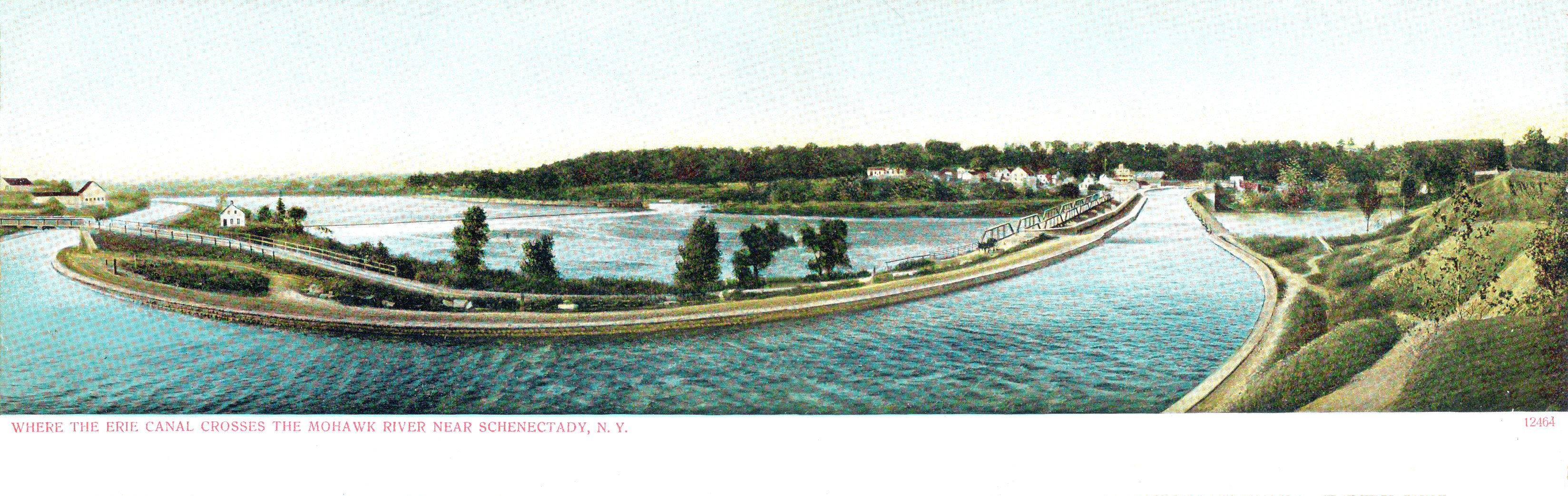
After entering Niskayuna, the path crosses Aqueduct Rd and passes the ruins of the 610’ Upper Mohawk Aqueduct (also called the Rexford Aqueduct), behind the bridge on your left, where the original Erie Canal crossed back over from the left (north) to the right (south) bank of the river. (Here is a postcard view of the aqueduct crossing the river.) After Dunsbach Ferry, the bike trail circles around a sharp bend in the Mohawk River. The community within the bend is Boght Corners. First settled by the Dutch, it appears in colonial records as “The Boght” or “The Boght of the Kahoos,” “boght” an Old Dutch word meaning “bend” and “Kahoos” a reference to Cohoes Falls (pronounced Ca-hose’) on the Mohawk immediately below.
The original Erie Canal crossed the River at the tip of the bend at Crescent on the Lower Mohawk Aqueduct, at 1137’ the longest on the canal. Only a few stones from it remain today. The ride route then dashes down past the Cohoes Falls (at some distance) to the Hudson. Only two miles up from the mouth of the Mohawk, the 90’ falls and the rapids above and below were the most formidable obstacle on the course of the Erie Canal. The original canal surmounted it with a series of 15 locks on the south side of the river, No 4 to No 18, through the city of Cohoes, lifting the water 153’ in 5 miles. (The falls’ name means “Place of the falling canoe” in the language of the Mohawk.). The New York State Canal bypassed the falls a mile north on the Waterford Flight, Locks E-2 to E-6, gaining 169’ of elevation in just 1.5 miles, the steepest set of locks in the United States. Cohoes, in Albany Co, was originally a Dutch settlement. In the 19th century, it came to be known as the “Spindle City” for its cotton textile mills, most of them operated by one company, Harmony Mills. Troy, the destination, is across the Hudson. It is the seat of Rensselaer Co, named for one of the original Dutch families. The native people of the region at first contact were Mohican. At the origin of the Erie Canal, as well as a branch canal to Lake Champlain, Troy was an important transshipment center. A local steel works was the first in the US to adopt the Bessemer converter. Local industries fashioned the iron and steel into swords, gun barrels, shells, and other ordnance and materiel for the federal arsenal across the Hudson in Watervliet (originally West Troy). The local textile industry specialized in shirts, shirtwaists, and detachable collars and cuffs. In 1823, a local newspaper published “A Visit from St. Nicholas” (“The Night before Christmas”), by an anonymous author whose identity is disputed. The Irish nationalist and labor leader James Connolly lived in Troy during a period of exile. He was one of 16 Irish republicans executed by the British for their role in the Easter Rising in 1916. And Jodie has told you about Uncle Sam Wilson.

Comments
Post a Comment